 Ohio. Ohio University is threatening to sell Dysart Woods, and the Ridges, betraying its trust to humanity, the nature conservancy and its integrity.
Dysart Defenders updated October 6, 2021
Dysart Woods is among the last of the .004 percent of old growth forest left in Ohio. Ohio University is threatening to sell Dysart Woods, and the Ridges, betraying its trust to humanity, the nature conservancy and its integrity.
OVCC would have longwall mined the entire forest, with devastating effects. Mining was reduced to room and pillar, with larger pillars than normal, through eight legal appeals filed by Chad Kister, Dysart Defenders, the Buckeye Forest Council and Ohio University (who hired Kister until they sold out to the coal company, and Kister founded Dysart Defenders to continue the struggle to protect Dysart Woods)
Still, the mine voids need to be backfilled, before they collapse and damage the forest. Some damage is inevitable, and OVCC needs to be held accountable for that damage in court. Please send information about the impacts on Dysart Woods to ckister@chadkister.com
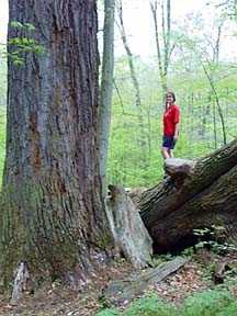 Dysart Woods |
or | 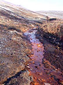 OVCC Coal refuse dump |
Ultimate hearing date Friday, Oct. 15 at 2 p.m. in Columbus for Dysart Woods!
Dysart Defenders carries on appeal. hearings: July 7-9, July 25-26, August 10-12 and August 30-September 1
Ohio University sells out Dysart Woods!
Dysart Defenders needs help with our legal expenses. The appeal to stop mining under Dysart Woods has hearings coming up in April or May.
Lots more information at the Buckeye Forest Council web site
Athens Messenger article: Buckeye Forest Council and Dysart Defenders appeal permit to mine Dysart
POPLAR hold sit-in in OU President Robert Glidden's office, OU agrees to appeal permit.
Athens Messenger article: groups to appeal permit
ODMR passes permit to undermine Dysart Woods
Dysart Defenders hold successful rally (POST article)
Banner hung in front of OU's main administration building, Cutler Hall, asking OU to appeal the -12 permit
Dysart Woods rally Thursday, May 29 at noon at the West Portico of Memorial Auditorium on College Green, Athens
Email a letter to be delivered to OU President Glidden at the rally (he will be there himself) or mail to POPLAR, P.O. Box 571; Athens, OH 45701
OU POST update about Dysart Woods
Press Release about ODMR finding of 255 violations of law in OVCC permit
Wheeling Intelligencer article on PROPOSED OU compromise
Ohio University considers compromise on Dysart Woods
Athens News article about Student Senat Resolution to protect Dysart Woods
Feb. 27 OU POST article about Student Senate Resolution
Student Senate Passes Resolution to protect Dysart Woods
Email, call and FAX Governor Taft
Cleveland WRUW radio interview with Dysart Defenders coordinator Chad Kister (1 hour, 25 megabyte mp3 file).
Athens News Article about Dysart Defenders meeting with Ohio Division of Mineral Resources Chief Michael Sponsler
Ohio University announces it will hire environmental lawyer
Dysart Defenders holds successful street theater demonstration and turns in 3,000 petition signatures to Ohio University President Robert Glidden.
Athens News Article about the event
Dysart Defenders overwhelm coal company seven to one at public hearing Thursday evening!
Chad Kister's testimony
Public hearing on permit to undermine Dysart Woods September 19 at 6:00 p.m.
Note: Dysart Defenders' coordinator, Chad Kister's phone number has changed to (740) 753-2278
Dysart Defenders holds press conference at Ohio Division of Mineral Resources headquarters in Columbus
Dysart Defenders needs help to appeal to Ohio Supreme Court: time is running out!!!
Destiny of Dysart still Unknown: The POST, June 26, 2002
ODMR deems permit to undermine Dysart Complete
Flier for Wednesday rally (please print, copy on re-used or recycled paper and post)
Dysart Defenders outnumber coal company more than two to one at public hearing Wednesday
Post letter to the editor published May 7
Public Hearing May 15 for Dysart Woods
Map of all pending permits
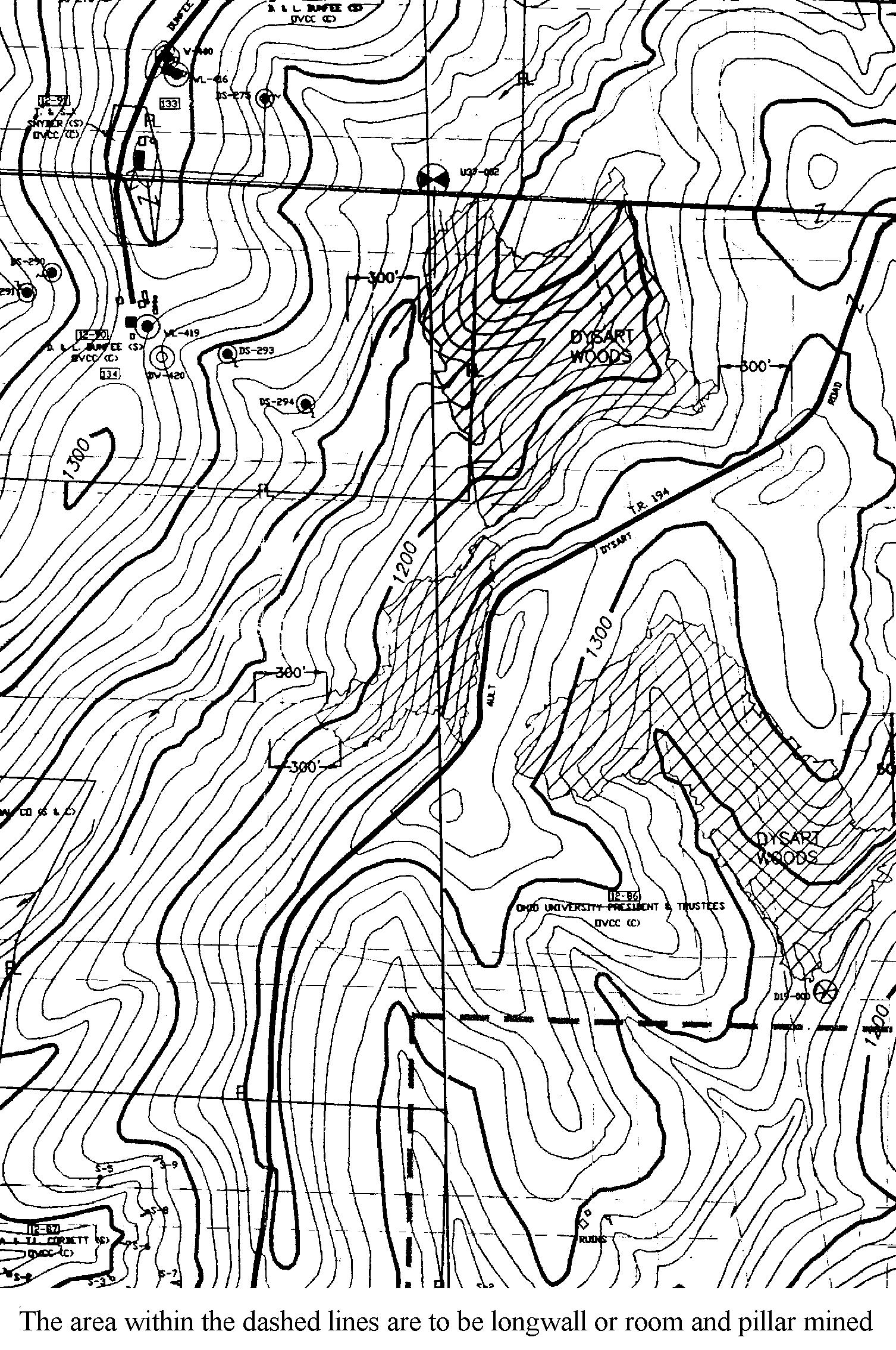
Map of the -12 permit which would undermine all of Dysart Woods. The -13 and -9 permits are to access the -12 permit area.
ODMR Schedules hearing May 15 on new permit to undermine Dysart Woods Watershed (in addition to OVCC's proposal to undermine all of Dysart Woods, including the Old Growth portions!)
Dysart Defenders appeal hearing April 16 to stop undermining of ancient forest
Dysart Defenders appeals permit to mine under Dysart Woods
Please print petition, get signatures and mail to: P.O. Box 31; Athens, OH 45701
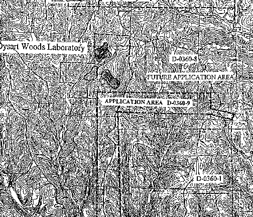
Map of D-360-9 permit and Dysart
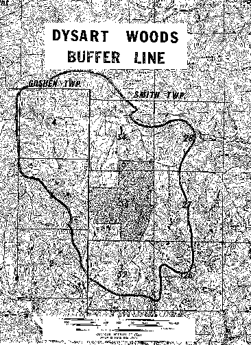
Map of Dysart Watershed Buffer
The full text of the 47 page appeal (100+ pages with appendices that will soon be posted)
ODMR approves mining permit area under Dysart Woods!
Ohio Valley Coal Company applies to mine under Dysart Woods
Dysart Defenders appeals Ohio Reclamation Commission Exemption Decision
Benefit Concert needs organizers: email chad@dysartwoods.org
About Dysart Woods
Dysart Woods is among the last .004 percent of remaining ancient forest in Ohio. It is the most significant stand of mixed mesophytic virgin forest left in Ohio, and is among the most endangered ecosystem in the world. Dysart Woods is owned by Ohio University and is a National Natural Landmark. But Ohio Valley Coal Company has a pending permit to mine right under Dysart Woods. Please join Dysart Defenders in our effort to save this ancient forest.
Dysart Defenders has two active appeals of the lands unsuitability for mining petition, and an appeal of OVCC's coal waste dump just upstream from the endangered Eastern Hellbender, America's largest aquatic salamander. The waste dump is for coal OVCC wants to mine from under Dysart Woods.
Directions to Dysart Woods
From Columbus: take Interstate 70 East. Go to exit 208 (they follow the mile marker numbers) and take a right (south) on 149. Go about 5 miles until the road dead ends on 147/149. Take a left. Go to the little town of Belmont and take a right on 147 East. Go about 5 miles until you see the Dysart Woods sign on the right. Follow the next sign to your right. Next, go straight to the grassy parking area about a half mile down the narrow gravel road on your left.
The blue trail goes down from the parking area, loops around over the road to the red trail that is on the opposite side of the ridge top as the blue trail. It can take some searching to find the trail head.